![]()
OK - I do hate "blogs"; who except one's family and closest friends are really interested in a person's diary, their thoughts and ramblings? But I think that in this case it is the perfect way to keep my students, friends and family up to date on my trip to, participation in, and return from, the CPE Nationals in Sacramento CA. This trip runs from Sunday May 28, 2006 through (hopefully!) Sunday, June 11th, 2006.
Each day, when possible (when I have access to the internet) I will add to the top of this page my latest notes and experiences. I hope you enjoy!
Trisha
Trip to 2006 CPE Nationals in Elk Grove/Sacramento, California
Sunday, May 28, 2006 - Sunday, June 11, 2006
Day 15 (Sunday, June 11)
This is it! One
way or another I planned on getting home today. I'm writing this on Monday
afternoon, after trying to recover for the good part of the day.
I thought I was doing a good thing on Saturday night by
staying in Moline, IL. I thought it was closer to Chicago than it was (it
was about 120 miles west of the city). I was still in the Central time
zone, so there's an hour lost right there. And I had planned on getting to
bed early, which didn't happen (it never seems to happen!). Anyway, I got
out on the road by 6:20am Central time. The map program said I had over
900 miles to drive, so I planned on very short and minimal stops during the day
to get home as soon as possible.
I tried as best I could to make up time, but it was
very hard to do. I could see I'd be getting home around 10pm, so just
decided to grin and bear it -- at least I was getting home tonight! I got
gas in Herkimer NY, only 2 hours from home. I was longing to see my other
2 dogs and sleep in my own bed.
As for most days when I did mostly traveling without
sightseeing, my van took 3 tankfuls of gas, which ends up costing me about $130
a day.
I pulled into the driveway in New Lebanon at 10:40pm,
and had driven 990 miles in approximately 15 hours to finish my journey.
I greeted the dogs and my parents with happiness, as
did Sandy and Buddy. It's good to be home :-)
Later tonight I'll add the pictures from the trip home
to this blog. Thank you for reading!!
Day 14 (Saturday, June 10)
Today was a driving
day - after visiting Harold Warp's Pioneer Village in Minden, NE, that is.
I spent too long there, over 3 hours! There was just so much to see there;
they have 26 buildings all chock full of memorabilia (pioneer stuff,
automobiles, airplanes, tools, farm machinery, collections, sod house,
appliances, one room school, etc!!). It's hard to explain all the things
they had there - their website is
www.pioneervillage.org I have been to museums and displays of antique
Americana, but this was simply overwhelming, there was so much! They also
had interesting little factoids posted in various places, such as how Rand
McNally originated, and how pop tops for aluminum soda/beer cans were invented.


After leaving Minden, I headed East on I-80, which is
what I would do for the rest of the day. I went through Lincoln and Omaha
Nebraska. The weather was dreary all day, overcast and humid, but it only
rained for a couple short stretches of road. The land in Nebraska is all
flat and the road straight, so I had to keep varying listening to my book on
tape, the radio, and music CD's to keep myself alert.
Finally I passed into Iowa - I think the welcome sign
read "Fields of Opportunities". I think Nebraska's sign read "Land of
Enchantment" (or was that Colorado?? I'll have to look that up sometime...)
One town listed on an exit sign was Wiota, Iowa.
Here's a town with 6 vowels and only 3 consonants... Both have I O and A
in that order :-)
I saw a few more dead deer, 2 in a 10 mile stretch, in
Iowa. The speed limit here was 70 - in Nebraska it had been 75.
I decided to end the day before dark tonight - I am
staying at a Motel 6 in Moline, IL, which I just passed into in the last 10
minutes of my drive. I'm a bit Southwest of Chicago, so with an early
start tomorrow should get home by around 7pm!
I have all my pictures downloaded onto my computer now,
but will wait to upload them to this page until I get home, as I don't have a
high speed connection here in the hotel. So, check back on Monday for some
awesome Grand Canyon pictures!!
Day 13 (Friday, June 9)
Today I started out in
the mountains - at around 6000 feet. I forgot to mention yesterday that
while negotiating all those mountain passes, I saw numerous state parks and
access to trailheads. Wow, you could really get lost out here being the
outdoorsperson!
I went through some big Colorado towns:Vail (8200'),
Breckenridge, and Steamboat Springs, to name a few. Just east of Vail
Route I-70 went through Vail Pass Summit, 10,603 feet high, and there was a
gorgeous rest area and scenic area at the summit. With snow all around
(not just on the peaks, on the sloping hills, too, and at 11am probably only
around 55 degrees, it was beautiful. There had been some sort of bicycling
accident, there were numerous EMS vehicles there. It looked like 2 people
getting attention. There was a trial/bike path that paralleled the road
for miles either side of the summit, and I had seen lots and lots of folks
bicycling it on the way to the summit.


Route 70 winds skillfully between and around the mountains,
making the toll on a vehicle not that great at all. In one case they put a
tunnel through the largest mountain (not sure the name); it's the Johnson
Tunnel, completed in 1979. It was at least a mile long, I think, and well lit
:-)
Going east to Denver, the road kept going up and down
in elevation, uphill, downhill, uphill, downhill...
I took Route 25 North to get to I-80. With the
Rocky Mountains on the west it was a very scenic view - and I can say I went
through some of them!
I passed into Wyoming, including the city of Cheyenne.
Then came Nebraska.
I took a slight detour North to Scott's Bluff National
Park near the end of the day. It's the site of the Scott's Bluff National
Monument where pioneer travelers passed through on their trip to the west coast
while negotiating the Oregon Trail. The site was impressive, nice views.
However, I had hoped to see ruts left from wagon tracks (they said some were
still visible), but didn't see any close up. I think I saw some from the view
from the top of the bluff, but I will see when I download the pictures into my
computer (not enough time last night).


I just about caught up to my itinerary by driving until
11pm last night; I ended up in Kearney for the night. Now I'm in the
Central Time Zone, so am getting closer to home!
Day 12 (Thursday, June 8)
Wow, day 12!
Since today was pretty much the last sightseeing day, other than a possible stop
or two in the midwest, I'm starting to get anxious to get closer to home.
The past 2 days I've not really traveled that much closer to home, just
"meandered" around Arizona and New Mexico.
Today I started out a little later - I needed to sleep
in this morning since I was pretty tired from the past day's late night drive.
I got going around 9:30. First I went to 4 corners - 4 states meet at a
point (Arizona, Utah, Colorado, and New Mexico). This was on an indian
reservation, and they waived the $3 entrance fee because the bathrooms were out of
order. They must've had about 50 porta potties there! When I was
there, around 10:30, the skies were dreary and it was threatening rain.
But there were still about 20 cars there. It was a raised monument with
concrete slab etched with the point where the 4 states met plus lots of other
state seals and text; you could go up and stand anywhere on it and get your
picture taken.


I heard on the radio while leaving that "on this day in
history" WGY in Schenectady NY in 1929 (I think) had the first ever TV
broadcast. It was neat to hear about WGY and Schenectady from 4 corners...
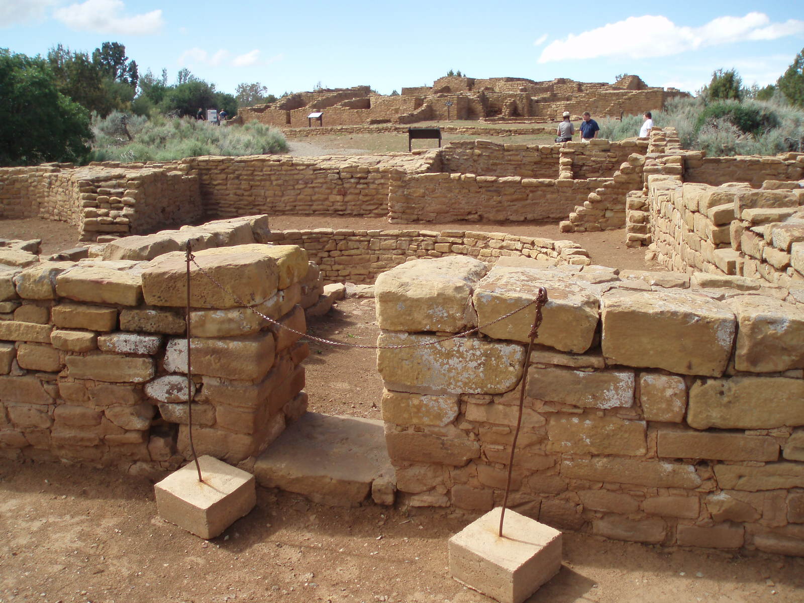
I entered Colorado, on my way to Mesa Verde. It
was at an elevation of 7000 feet, and there was wonderful scenery within the
park on the drive up to this elevation. I stayed 4 hours, longer than
planned - I was fascinated by the ruins and excavation sites. Plus, it
took awhile just to drive around from spot to spot. I envied the folks who
paid (and it was probably not cheap to do so) to take the strenuous hiking tour down to see the cave
dwellings close up - it included ladders and steep inclines/declines.
During my time here the skies turned clear and the views became gorgeous.


Finally, around 5pm I left Mesa Verde. I headed
North on Route 550 from Durango towards Grand Junction and eventually I-70.
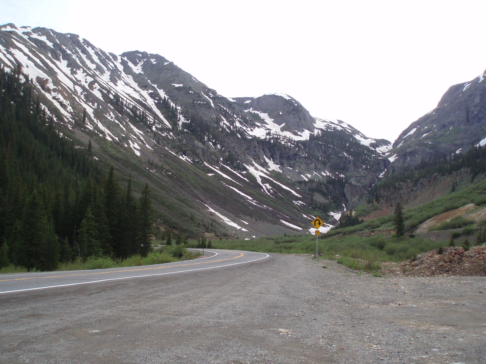
I was going into ski country now, going through the San Juan Mountains.
The rain was gone, and the sky was partly cloudy now. I got out at a
scenic rest stop at Molas Pass, an elevation of 10,970 feet! Colder
weather and snow-capped mountains were around us. Not long after that we
had to descend -- and it happened quickly. I've never seen so many
switchbacks, and at most times there was no guard rail and very little edge to
the road. I kept it in low gear to save my brakes and took my time :-)


Coming around one turn suddenly there was a small town
in the valley between mountains -- it was Silverton. They were nestled
nicely into the valley; I didn't get a picture because there was nowhere to stop
to get one, but it was very idyllic. Another 20 or so switchbacks and
there was another similar town called Ouray. Same type of approach, but
this time they were also known for their hot springs. After Ouray the
roads straightened up and flattened out, and the speed limit went up to 60.
By now it was after 8pm, so I stopped at McDonalds when getting to Montrose to
feed myself and the dogs. While there it started pouring rain and
thunder/lightning in the distance, and there across the parking lot was a
Quality Inn hotel. So, I decided to stay here overnight!
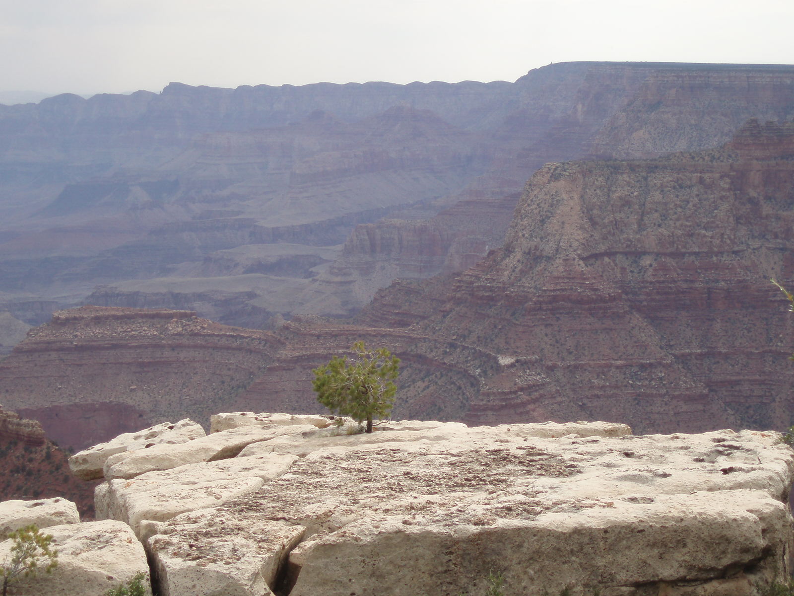
Day 11 (Wednesday, June 7)
I headed out around
7am to see the rest of the Grand Canyon. Arizona never goes to daylight
savings time, so it was like still being on Pacific time. The day was
cloudy and threatening rain (it had rained briefly overnight), and as the
morning went on it got colder and quite windy. There were awesome views at
every spot, including Moran Point, my favorite other than the North Rim (this
was a close second by comparison). I took Sandy for a walk on about a 3/4
mile loop of the rim trail


I need to look up sometime where the final scene from
the movie "Thelma and Louise" was filmed. I was only on park roads at the
grand canyon, my guess is that there's a road on the west side that leads you up
to the rim.
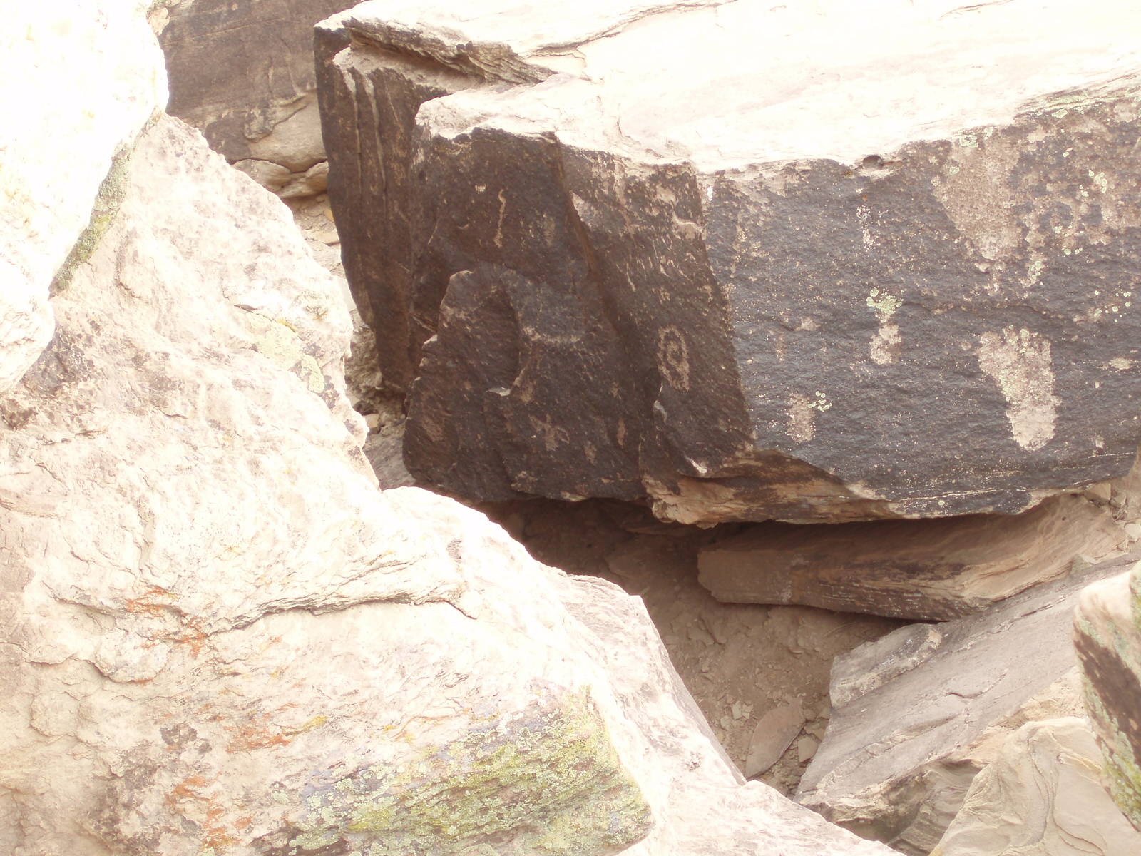
They had indian ruins at Tusayon - it was very
interesting.
I left the Grand Canyon, and went south on 89 to pick
up Route 40E. I stopped at Sunset crater, a volcano that erupted in the
year 1180.


I saw a billboard as I approached Winslow AZ -
"Standing on a Corner in Winslow AZ" - a take on the Eagles song from the 70's!
I also was on Old Historic Route 66 for awhile (I guess it doesn't really exist
any more) while on 180 on the way to the Petrified Forest National Park.
I think mostly because I had just been to the Grand
Canyon, I wasn't that impressed with the petrified forest. What can beat
the Grand Canyon, anyway? The other issue was that I got poured on while
going around the first exhibit, and then was threatened to get rained on again
every other time I got out of the car. There were thunderstorms around,
too, so while I had planned on taking the dog(s) on some of the short loop hikes
(they are allowed at this park), they ended up staying in the car. There
was one loop called Crystal Forest, which of course I visited - it was petrified
trees with quartz crystals embedded in them. Later, I saw more Badlands,
very similar to those in South Dakota. Near the end of the park was
another indian ruins and excavation site, this one larger, of the Puerco Pueblo
indians.


The Painted Desert, which afforded awesome views near
the end of Petrified Forest NP, was much Badlands, but the color was truly
red-tinted.


I went on Route 40 East to New Mexico, then turned
north on Route 491 towards the 4 corners. I ended up (finally, at 10pm!)
finding a hotel room in Farmington NM for the night.
Day 10 (Tuesday, June 6)
I'm writing this from
a campground at the South Rim of the Grand Canyon, so you won't be reading it
until probably Wednesday night.
Today was a fun day -- although another squelcher, it
got up to about 100 degrees in some areas. I left St. George around
7:45am, went east on Route 9 through Zion National Park. There were some
gorgeous views here, although I balked at the $20 entrance fee as I was only
going to be in the park about an hour. But, the mile long tunnel made the
price worth paying. I always liked tunnels, but the second I got into this
one I was plunged into almost total darkness, even with my headlights on -- it
was scary! I felt like I was on a ride in an amusement park :-)
After I realized my headlights were indeed working, after about 10 seconds I got
some night vision back. Every 1/10 mile or so (maybe more often) there was
an opening in the side for light to pass through (thank goodness!), and
sometimes it also afforded an awesome view, although I couldn't stop because the
road was narrow and there was no pullover area.


I ended up back in Arizona after turning south on Route
89A towards the North rim of the Grand Canyon. On the way there was a rise
in elevation to 6700 ft, and a fantastic overlook called La Fevre, it was a view
of the Vermilion Cliffs.

On Route 67 South now, elevation went up to 6700 feet.
By the time I entered Grand Canyon Park we were at 8725 feet. I paid $30
instead of the $25 fee to upgrade to a year's pass for all National parks (this
included a credit from the Zion National Park from this morning). I
planned to visit 2 more national parks in the next few days, so figured this was
a good deal.
The North Rim ... Awesome! I was there around
midday, and it was hot and high up, and I didn't bring water from the car.
I had to pace myself going back from the 1/4 mile (guess) walk from the vista,
which was a steep incline, but it was still worth it
.


I exited and headed towards the south rim, but had to go
North first to get back to the main road. The south rim is 10 miles away,
but 215 miles drive on the road.
I went through the Vermilion Cliffs closeup now on
Route 89 East, and there were more awesome views. I'll upload them when I
can.


Turning South on 89, I went through the Painted Desert
and Navaho Indian Nation. Then, I turned westward into the South rim of
Grand Canyon. It got a bit late to do more than go to the first overlook
(which, again, was awesome),


so I drove to a campground in the park, where my
doggies and I are now relaxing as the temperature cools down nicely. It's
supposed to get down to 40 degrees overnight so should be good sleeping weather.
Day nine (Monday, June 5)
I left the hotel room
in Rancho Cordova (about 10 minutes east of Sacramento) at little after 8am, I
had to get my oil changed and there was a Jiffy Lube nearby that didn't open
until 8am. So, my long driving day didn't start until 9am.
I traveled south on Route 99 to Bakersfield before
heading east on routes 58 and then 15 towards the north rim of the Grand Canyon
(where I'll visit on Tuesday). I stopped for gas in Fresno, and the gas
was $3.39/gallon!! However, later I'd find an even more outrageous price
(and had no choice, I wanted to gas up before hitting the desert area, didn't
know when the next stop might be) in Baker. This is in the "high desert",
the Mojave Desert, just west of the Nevada border. The price here was
$3.69/gallon!


Oh, and the heat...as soon as I started driving east on
Route 58 the temperature rose, and the scenery turned to mountainous and desert.
The temperature in this area was 102. I passed just north of Edwards Air
Force Base, and while I didn't see anything, took a picture anyway :-)
This was a fire zone danger area - I passed by several fire trucks and lots of
smoke as they had just put one out, and about an hour later saw a thin line of
fire off near an exit. It was just so hot and dry outside, the fires just
flare up.

I saw a road in the area named Zzyzx Rd. How'd
you like to live there?
When I stopped in Baker to buy gas for an absorbidant
amount, the temperature gage on a sign outside said 110...
Not long after Route 15 went up in elevation from under
2000 feet to 4000 feet in about 15 miles. I had my A/C on, and about
halfway through noticed my car's temp gauge was up a little bit; hoping
everything was ok, for the next 10 miles I alternated between turning the AC on
and off (it got hot in the car quickly with it off, even with the windows open).
This did the trick of keeping the temp just above the center line, which is
usually where it steadily stays. As soon as we were done climbing I turned
the AC on full and the temp held steady at the center line. I checked the
fluid level the next morning and barely an ounce was gone, so I guess this was
totally normal. Lots of people in that stretch had their windows open on
their cars, so they were either crazy or were being nice to their cars, too.
I saw some cars on the side of the road in this area, presumably overheated.
I passed into Nevada, and went through Las Vegas around
5:30pm. Not a gambler, and not being at night, it wasn't that big of a
deal. I think at night it probably looks impressive.
I went through a corner of Arizona on my way to the
southern corner of Utah, where I planned to stay the night. I passed
through the Virgin River Canyon on I-15, which was beautiful - it was 7pm, so
the setting sun cast a red glow on some of the mountains and valleys.

I stopped in St. George Utah, now on Mountain time, to
spend the night.
Day eight (Sunday, June 4)
Well, this was it!
The last day. Again, it was unbearably hot (high was above 90 again), but
at least today there was a breeze to help you feel cooler when outside. I
had to run Snooker first thing today in the building -- there were no contacts,
one 2 jump combo, and 3 curved tunnels close to each other (#3, 5, and 6 which
was in the middle, and was only 8' long!). Sandy was the second dog in
(the 8" class ran first today in my rotation). I planned a conservative
course as I didn't know how fast she would be on day 3. She ended up being
fast and excited, so we had no problem; I did a 5, 6, and 3 in the opening, and
made it to the table before the whistle blew. I ran Budd y about 20 dogs
later; I must've miscued him because after the first red jump he took another
red jump out to the side. Oh well!
I had to wait about 3 hours before my next run,
standard. So, I had 3 hours to think about my blunder with Buddy :-)
Sandy was first dog on the line in std, so we had to wait awhile while they got
set up. She handled it well, I had wet her down as usual - we ran fine and
got a Q. So did Buddy.
Last class was Colors, one course had the teeter, and
the other had no contacts at all but a nasty approach to the weave poles; I
opted for the teeter course. I probably should've run the no-contacts
course with Sandy, as it took her at least 7 seconds to do the teeter, I think
it was hot and she didn't want to move her feet! Earlier in Std she slowed
way down on top of the dogwalk, I think that was hot on her feet too. She
just barely made time, but all that counts is that she got the Q. Buddy,
on the other hand, had another wandering/distracted moment, then missed the
weave pole entry; he ended up 4 seconds over time.
I figured there must have been some dogs that ran clean
all weekend, so we were out of it for HIT.
About an hour later they were done calculating the
results:
Sandy got 4th place in Jackpot and 2nd place in Snooker!
Sandy took high scoring All American, a nice glass plaque etched with the event date and award!
Sandy also took 5th place in 12" games (overall for all 6 games, all levels combined for the 12" class, probably about 50 dogs in this class)
There were 4 perfect weekends; 3 went to veteran dogs.
I am very happy with how Sandy did - not bad for an 11-1/2 year old dog! Despite the one non-Q, she really did run perfectly all weekend for me, no bobbles at all. Buddy ran nice most of the weekend, just had a few oops moments. But, he did his weave poles every time (other than the missed entry in Colors), which for him is awesome.
I'm heading out tomorrow morning on my trip back home. I'm going through the Grand Canyon, and will probably only be posting updates sporadically, but I'll continue my notes as often as I can on the trip home.
Day seven (Saturday, June 3)
Another hot day - it
got up to 93 today. It wasn't as windy as yesterday, so I felt the heat
more today. My dogs did really well despite the heat. In fact, I
think they ran faster than yesterday! I made sure to wet them and keep
them out of the sun before each run, and Sandy wore a terricloth coat I soaked
down before each run. Plus, they had fans on them in the crating area in
between runs.
They ran Standard around 10am -- both ran clean, under
time. There were 2 dogwalks and no A-frame to perform, which made Sandy
happy! Second to run was Jumpers, around noontime, inside. By now it
was hot and stagnant air inside - the jumpers course was nice and flowing, with
a serpentine at the start which required turning the dog away from 2 tunnels.
Both dogs ran this course nicely - and I thought Sandy ran this course faster
than standard. However, she came in 2 seconds over time, and you have to
be clean in Level C, so she got her first NQ. Buddy was just a fraction of
a second under time. You pretty much have to run clean at the nationals,
so Sandy's shot at HIT was probably gone.
Last in the day (and we were in the last group) was
Jackpot. It was traditional, with the difference being you needed only 20
points in the opening and could start the gamble before the whistle blew.
I did that with both dogs, as it was hot and the end of a long day, no need to
keep them out there any longer than necessary! Sandy got the gamble and Q,
but I miscued Buddy slightly (not sure just what I did, I have to wait to look
at the video to see what happened) and he didn't get the gamble. Now each
of my dogs is 5 for 6. Oh well... they both ran very nicely for me today!
Day six (Friday, June 2)
Check in for the
nationals was early; I had to be on the road by 6:15 as it took 1/2 hour to get
to the show site. It was going to be a hot day, and I had put a crate,
mat, and electric cords in a spot just inside the arena next to a power outlet
last night, so was prepared. The only thing I forgot was the string
cheese, which I realized halfway to the site was in my refrigerator in the hotel
room. Oh well!
They had it set up similar to the USDAA Championships,
with 6 groups. Whatever group you were in you had all your dogs in, and
only walked/ran with that group. There were 3 runs today (std, wildcard,
and fullhouse) in 4 rings, standard was in 2 rings at once.
I ran wildcard first; Buddy wandered around a bit in
between obstacles, I think he was out of sorts (he was more normal for his other
runs today). Sandy ran nicely, I thought pretty fast. Both dogs did
a tough little jump sequence nicely (which most people handled as a wrap, but I
brought my dogs around the other way to give them a smoother path). It was
around 10am, and already hot out. I just made time with both dogs, and
suspect the times were set a little tighter than on a normal trial weekend,
which makes sense.
Next was standard; a nice course with several tricky
sections. It was now noon, and very hot, although luckily a breeze
kept the heat manageable. Both Sandy and Buddy ran clean, and again not
much under time (Sandy about 2 sec under, and Buddy 8). I was pleased with both
runs.
Last, about 1/2 hour after standard, in the covered
indoor dirt ring, we ran fullhouse. Both dogs ran nicely, got enough
points, and got to the table in time, so 2 more Q's.
I was back to the hotel room by 4pm, and am going to
catch up on sleep tonight :-)
Day five (Thursday, June 1)
After a short night, I
got up early and was on the road by 6:30am. I had forgotten about one more
time change, from Mountain to Pacific time zones, and was pleased that it would
mean I would get into the Sacramento area in time for check in, which was from
4-7pm.
I saw more flat land, fields and cattle farms, with
mountains in the far distance, in the morning. I guessed the fields
were potatoes, as that's what Idaho is famous for!


I passed into Nevada, and the first town was Jackpot -
fitting, as I was going to a CPE trial! It was a gambling town, as seemed
to be many others in Nevada, likeWells and later Reno and Sparks (Nevada seems
to have cornered the market on gambling towns). I was travelling on Route
93 South on the way to re-connecting with I-80. The speed limit was 70
mph, and this wasn't a divided highway; every time a truck went in the other
direction there was quite a wake behind him! It was also windy, I believe
the elevation was quite high. And, it was hot too.
A rest area not far into Nevada was apparently closed;
but what I noticed was the sign at it saying "use of firearms at this area
prohibited" - as if people would have to be told which rest areas they are
permitted in ??! Needless to say, I wasn't about to stop at any of these
rest areas even if they were open! And, about 1/4 mile after this closed
rest area was another road sign, "report highway shootings by dialing...".
Yikes! That's the result of all of these gambling towns, I guess.
The landscape was flat, with craggy
(bushes/dirt/rocks), straight roads, mountains at right (west) and ahead
(south). At a rest stop after reconnecting with I-80 westbound, I let the
dogs out. It was very hot, stifling, and Sandy didn't even want to walk, I
guess her feet hurt from the hot ground/dirt. The mountains in the
distance didn't really look any higher than my current elevation. It felt
like we were on top of the world, there were several small towns for about a 60
mile stretch, in between there was desolate landscape with mountains in the
distance.
The other interesting thing about Nevada was that there
were even mini-casinos at the rest stops! Also, I saw 2 prisons in this
area - I guess the high isolated region lent itself well to this.
I went through Donner Summit into California - striking
scenery here.


Then I descended to 2000 feet in the next 10 miles or so, and
then onward to Sacramento. Unfortunately, however, I arrived just east of
Sacramento on Thursday afternoon at 5pm, right in rush hour! I got to the
show site by 6:30, and was settled in my hotel room by 8pm.
Day three (Tuesday, May 30)
I'm putting this in on
Wednesday, as I have a story to tell about Tuesday and the reason I couldn't get
online to post my trip update. So, therefore, I am posting Tuesday above
Wednesday.
The day started off fine, I left the Kennebec South
Dakota campground at 6:45am. I enjoyed hearing the interesting mix of
music played on local radio stations (many old tunes, some I've never heard
before, mixed with current stuff, but mostly old country tunes). I saw
billboards for places I wish I could go to visit but had no time to on this
trip, like: De Smet (a huge Laura Ingalls Wilder museum and homestead), the
Badlands, and the Black Hills. Well, I decided to go through the Badlands
after seeing the amazing view in the distance. It was well worth it,
amazing red jagged rock formations rising up out of the prairie. I was glad I
took the extra 2 hours or so to take this detour! I'll put pictures
up from my digital camera when I have time either Thursday or Friday night.


I next visited Mt. Rushmore, and the friend that told
me that she wasn't that impressed with it was right. Mainly, she said it
wouldn't take long to see-- I skipped the parking part and drove by twice to get
a picture, then stopped about a mile later on to get a profile view photo.
The roads in the area were very hilly, switchbacks and such, and I could smell
the brakes/melted rubber after getting to the bottom of one hill! After leaving Mt. Rushmore area, the rain started
coming down. I had planned on going to Custer State Park, just south, next to
see Buffalo, and started on the road. It was 20 miles, and not open to
trucks or RV's, and there were numerous notices of the road being closed in
winter, no winter maintenance, etc. It had an extremely steep grade, plus
several 180 degree turns to 1 way tunnels! About 7 miles into it, with
more than 10 to go and it still pouring out, plus I smelled that my brakes were
already heating up, I decided to quit the attempt and continue on westward.
I was disappointed at not getting to see Buffalo.


Driving into Wyoming I was greeted with a big road sign
reading "Wyoming Welcomes You". They also have a 75 mph speed limit on
I-90, as well as 65 mph on main state roads (like our local Route 20, 22, etc)
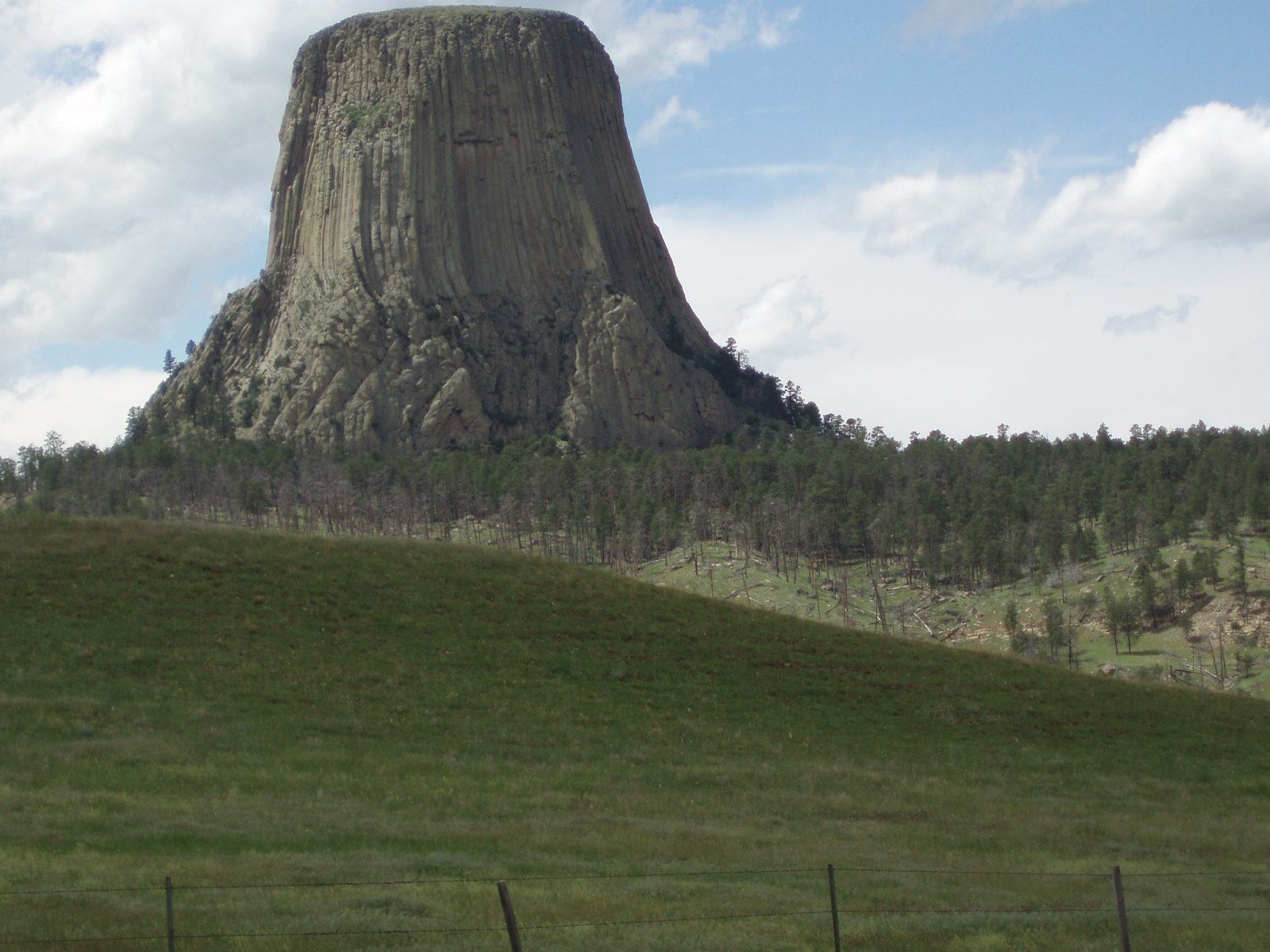
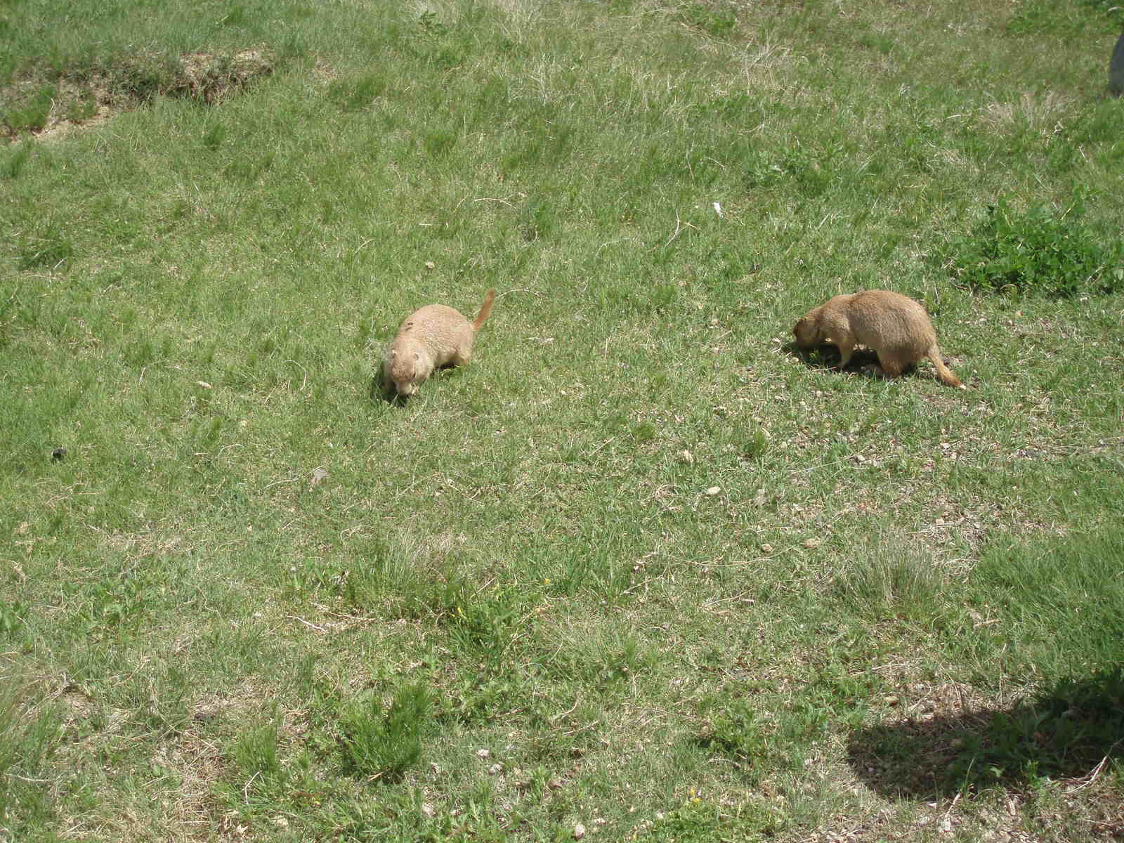
I was on my way to Devil's Tower now, another slight
detour I had planned into the trip. It was worth seeing, very impressive,
although a bit off the beaten path. I was thrilled to see dozens of
Prairie Dogs, and got several pictures - they are so cute!


In this area (near the Big Horn Mountain range) all the
roads have signs noting closures if the light is flashing due to winter
conditions, and barriers/gates that can drop down to block the road entrance.
I'm guessing the roads are closed often in the winter.
There was a storm that I kept trying to get West of
(that I first experienced at Mr. Rushmore), that was obvious to predict as you
could see at least 50 miles in each direction and the sky was very telling as to
where it was storming/sunny/etc. Also of note, as well as the rock
formations (like at the Badlands) being reddish in color, the roadways had a
good deal of red tint to them as well -- I guess they mix the dirt in with the
macadam?
Now, the harrowing end to my Tuesday: I was behind
schedule, and was trying to get as far as possible before overnighting - I drove
past Sheridan, decided to go a little farther, not realizing at the time that I
was next going through the Big Horn Mountains. This would've been fine,
except that about halfway up the steep grade my van's temperature gage
started rising (it was a very scenic drive, btw, but I wasn't concentrating on
that at the time!).


Despite my best efforts to not overuse the engine,
turn the heat on, etc, it kept climbing. I turned the heat up a notch,
which brought the needled down a bit, then it started to go up again, then I
cranked the heat some more. Finally I had no more options, and watched the
needle get very close to the top, and I thought I was close to the summit of the
road but wasn't sure. I then saw a sign for a visitor's center, just as
the engine light came on. I limped into the parking lot at 7:45pm, it had
closed for the night. I walked and fed the dogs while I waited for the
engine to cool off. The pay phone inside was busted, and I was at 8200 ft,
no cell phone signal, yikes! I checked the water level, and thought it was
ok -- I didn't check the radiator itself, just the side reservoir. After
almost an hour I tried again, the temperature almost immediately rose. I
almost turned back to the visitor's center to spend the night and wait for the
workers to come in in the morning (and knew it would be a cold night, that high
up, it was already pretty cold!), and saw a sign for lodge/resort 1/2 mile
ahead. Again I limped there. They had rooms, and accepted dogs!
The lady there said they had maintenance people that could look at the van in
the morning -- as we were in the middle of nowhere, at the summit, there was no
town for at least 15 miles, so this was welcome news!
Still, I went to bed with not much hope of being able
to continue on my trip. After thinking about it, I was sure the problem
was either a bad temperature sensor or busted fan, and thought either this would
take a day or more to fix, or wouldn't be possible since I wasn't in a town.
Thoughts swirled through my head of how I was going to get home, get the dogs
and my stuff into a rental vehicle, etc!
BTW, the room was very nice, the air crisp and cold,
and satellite TV in the room. It was called Bear Lodge Resort, and the
only negative thing was no phones in the room (plus no cell phone service up
there) - I didn't even bother to bring my computer into the room!


Day four (Wednesday, May 31)
Good news! The
maintenance guy (who used to live in Montpelier VT until 4 years ago!), found
that the only problem with my van was that the radiator coolant was just about
empty. No clue why it was drained so completely -- sure, I did some
demanding driving on Tuesday, but still, to drain a whole radiator without a
leak present? Anyway, I now carry 2 containers of radiator coolant, plus
(of course) water.
Interesting side story: there was an old Aussie/BC mix
there named Gus, who was a neat dog, really friendly. He once fended off a
bear that was trying to attack one of the family members. The owner also
told me that some local folks (a town about 20 miles away) hold dog agility
trials, and she would like to get involved with it too. Even at 8200 feet
you can play agility :-)
I saw some nice scenery going down Big Horn Mountain
(and my van temperature held nice and steady while I held my breath and watched
it).


I traveled West across the state to Yellowstone
National Park. I had lost a couple of hours, but decided that since I had
planned my route to take me through the park, it would take too much effort to
change the route now, so I decided to visit the park. I'm glad I did, even
though I ended up spending 2 hours there than I planned to (mainly because it
took awhile to get from one section of the park to another). One thing I
was thrilled to see, especially since I didn't yesterday, was lots of buffalo
(called "Clinton" ? Bison), in one case blocking the road. I have some
really close up pictures of them (all from the safety of my car). I
felt bad for my dogs, as I was pretty sure they weren't allowed in the park
(even on leash), so they had to stay in the crates in the car for about 4-1/2
hours. Luckily it wasn't a hot day, so that wasn't a worry for me.


I passed through the Teton National park next, and was
treated to more awesome views. Again, I'll post some on here when I get a
chance. Also I saw the Snake River, winding back and forth (and
which, for some reason, I passed over several times later tonight while
driving!)


Now I am getting back to I-80 (I'm to the north right
now, am heading south to pick it up tomorrow morning). I went through
Teton Pass, Route 22 west over the border from Wyoming to Idaho. The car
behaved very well through this steep grade up, over, and back down the other
side. After a lot of driving to find a hotel (somehow I never found the
section of Idaho Falls where the hotels were located, so went to the next major
town, Pocatello), I'm finally in for the night! Tomorrow I finish the trip
and can rest for 3 days and just run my dogs in agility :-)
Day two (Monday, May 29)
I started out at 6:30 am to make up for the previous
day's late start. Today I went through the states of Indiana,
Illinois, Iowa, and South Dakota. I finished up at a KOA (with wireless
internet, that's how I'm uploading this!) in Kennebec. I took I-80 all the
way to Sioux City, Iowa, where I turned north on Route 29, then West on I-90
(because tomorrow I am going to see Mt. Rushmore and Yellowstone Park).
I traveled an incredible 914 miles today! It
helped that I had an extra hour with the time change to central time in the
Chicago area, just about 1/2 hour after starting out this morning.
Along the way today I experienced the following:
-- a small Iowa farm town (I needed gas, so got off at the exit and drove
across the railroad tracks, between narrow streets with cross streets with stop
signs, all lined with small 50's or older looking shops and buildings -- no
McDonald's or WalMart here!


-- way too many dead deer on the side of the road - I counted at least 6,
plus a couple that had been run over a few too many times
-- not enough time to check it out, but I at least drove the "Lewis and
Clark highway", Route 29, which follows the Missouri River. About 1/2 hour
East of Kennebec, there was a rest stop with scenic overlook, which looked down
at the Missouri River and it's bridges, and there was a plaque commemorating
Lewis and Clark, too.


-- lots of beef cattle!
-- 75 mph speed limit in South Dakota, when there wasn't construction
slowing it back down again
-- billboards all over Route 29 and I-90 in South Dakota, for the
tourists, in 50's style, way too many to look at while driving!
Day one (Sunday, May 28)
After getting a late
start from New Lebanon (which I knew would happen on Saturday night, as 11pm
came and I wasn't near ready to leave first thing in the morning!), I had an
uneventful first day of driving. With the late start, my planned overnight
stop at a state park campground just south of Chicago (in Indiana) was changed
to a stay in a Red Roof Inn about an hour east of there, in Elkhart Indiana.
I travelled through the states of New York,
Pennsylvania, Ohio, and lastly into Indiana. I went 746 miles.
Nothing unusual to point out in terms of
scenery/sightseeing, as it was all familiar to me from past trips.